by Brian T. Lynch, MSW
We live on a watery planet, or so it would seem. When you compare the volume of all water on Earth to the volume of the entire planet, water is a small fraction of the whole. And liquid fresh water (from rainfall) is a tiny fraction of that.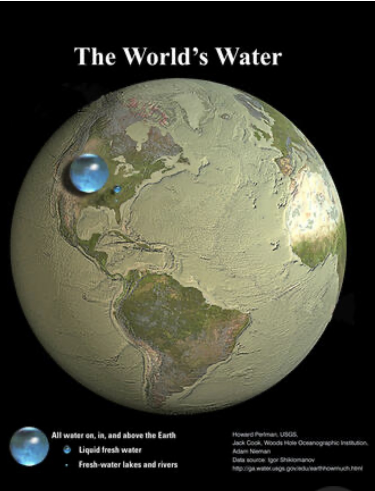
Another critical point is that understanding the status and condition of groundwater is essential. Our aquifers are being overdrawn due to rising water demands, thus risking the irreversible collapse of the aquifers. Our wetlands and rain recharge zones are shrinking due to overdevelopment, and chemical pollutants are contaminating groundwater supplies. This is where the importance of freshwater springs begins, because every spring is effectively a sample site for the groundwater below it.
WHAT ARE SPRINGS?
 |
| Outflow from the "Great Spring" in Kenvil, New Jersey. headwaters of the Black River |
In some cases, water from certain spring vents effervesces when subsurface pressures are released. In some dramatic cases, spring water shoots into the air in bursts of steam. We call these geysers. On the ocean floor, hot, volcanic water can flow out of sea vents, creating conditions that support abundant and often exotic lifeforms.
WHY ARE SPRINGS IMPORTANT?
The focus here is on terrestrial, freshwater springs, but even these have many variations that make them challenging to categorize and study. In addition to being samples of the groundwater conditions below, they are an essential source of surface water for the environment. It is estimated that groundwater contributes approximately 30% of the total surface water. This contribution helps maintain the baseflow of streams and rivers during dry periods, thereby modulating critical stream volumes and water temperatures for aquatic life. Many springs are also sensitive indicators of the impact of climate change and other environmental stress factors. It is estimated that spring habitats support about 10% of all endangered species, in addition to containing many rare and unique groundwater organisms that are vital to healthy river systems. [See “hyporheic” post]
WHAT IS LACKING IN OUR SPRING STEWARDSHIP?
It is broadly true, and specifically the case in New Jersey, that springs have received insufficient scientific study and attention. Nationally, there is no scientific consensus on spring classifications, nor is there a systematic methodology for comprehensive Spring assessments. There is also no systematic data collection, analysis, or monitoring of springs in this state. The Highlands Region of New Jersey, in particular, is characterized by higher elevations, abundant rainfall, many hills and valleys, and a dense network of brooks, streams, and rivers. Two-thirds of all residents in New Jersey depend on the Highlands for their drinking water, yet the great majority of springs endemic to this topographic region are unmapped. For example, in my three-square-mile town, I am aware of more unmapped springs than all the NJDEP-mapped springs in the county. The DEP’s stream mapping and study efforts have been commendable, but mostly ad hoc until now. This may be changing, and greater public awareness and interest would help.
WHAT IS NEEDED NOW?
The most critical and exciting need right now to promote spring stewardship in New Jersey is to identify all spring locations in the state. Very few springs are currently mapped. The NJDEP’s GeoWeb [https://dep.nj.gov/gis/nj-geoweb/] website is designed to pinpoint spring sites on a map throughout the state. However, the number of officially recognized springs remains small, and the current data provides limited information about each spring beyond its location, despite the fact that a good deal more information is collected at each site. A detailed scientific study of New Jersey springs encompassed fourteen springs. It was published in 2023 in an online publication, The Springs of New Jersey. A more comprehensive database for collecting and sharing spring information with the public is currently under development.
Meeting the need to identify springs in New Jersey requires what a national organization, the Spring Stewardship Institute in Arizona, calls Level 1 monitoring. It is a fieldwork process that specially trained volunteers can accomplish. Here is their description of this work:
“Inventory is a fundamental element of ecosystem stewardship, providing essential information on the distribution and status of resources and processes within ecosystems. Systematic inventory informs and therefore precedes assessment, planning, management action, and monitoring.
We have defined three levels of Survey Protocols:
Level 1:
Involves a general reconnaissance survey of springs within a landscape or land management unit, including brief (15 -20 minute) site visits to record georeferencing data and access directions, photograph the source and microhabitat array, and note the basic features of the springs ecosystem, such as spring type and context. This level of survey is useful for identifying the distribution of springs across a landscape, and determining the need for more rigorous inventories.
Level 2:
Involves a detailed survey of a spring's ecosystem to describe baseline physical, biological, and administrative context variables. These are detailed below.
We developed Springs Online with the capacity to contain and analyze individual or multiple surveys of springs across landscapes. For Level 2 surveys, we focus on six categories recognized by experts as being important to the ecological form, function, and sustainability of springs.
These categories include:
1. Groundwater geochemistry and flow
2. Geomorphology
3. Habitat and soils
4. Flora and fauna
5. Human influences
6. Administrative (legal and managerial) context.
Each Level 2 survey consists of two parts: a Springs Inventory Protocol (SIP) and a Springs Ecological Assessment Protocol (SEAP). The inventory component focuses on the physical characteristics and condition of the springs ecosystem. The SEAP component is a process of evaluating the inventory data to generate a condition and risk score in each of the categories. “

No comments:
Post a Comment
Please feel free to comment or make suggestions