by Brian T.
Lynch
Mine Hill is
a geographically and environmentally important area in New Jersey because it is
home to the headwaters of the North Branch of the great Raritan River, which
flows into Raritan Bay at Perth Amboy.
 The Raritan
River Basin is 1,100 square miles of some of the most beautiful land in
Northern New Jersey. It is the largest river basin contained entirely within
New Jersey. It provides drinking water to millions of residents, including
those who rely on the Round Valley and Spruce Run Reservoirs. The Raritan basin
is divided into three watershed management areas. To the South and East is the
Raritan Watershed Area containing the Raritan River itself, and both Green
Brook and Lawrence Brook. Due South is the Millstone Watershed Area where
waters run North from the confluence of the Stony Brook and Millstone Rivers.
But the bulk of the waters are from the Northwest, which is
divided into two main flows, the North Branch and the South Branch. The South
Branch starts in Budd Lake and flows south towards High Bridge. It then makes a
big loop to the East and back North where it joins up with the North Branch
just South of Somerville.
  It is the
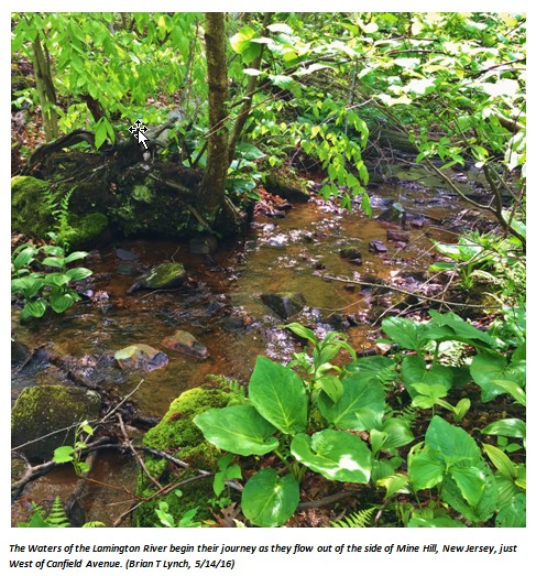
North Branch of the Raritan River Basin that interests me, because it starts just
West of Canfield Avenue. It floods some of the lush woodlands in the Green
Acres area known as the Dickerson Tract and the Rutgers track that forms the headwaters of the Lamington
River.
The
Lamington may not be a household word for most of us. It is only a little noticed
brook that runs out from the woods to cross Frank Street near George and First
Streets. It then wanders behind some houses until it crosses Dickerson Mine
Road to make a short passage into Mine Hill Lake.
If you are standing on the Mine Hill Beach and
look to the right you will see a point of land jutting out into the water. You
are looking to the North end of the lake.
The Lamington River discharges into the lake a short ways up from that
point.
Across the
lake and due South is where water from the lake spills into Randolph Park.
There is only a spit of land separating the two, as most old-timers know. But the Lamington
River rejoins its bank earlier, just West of that spillway into Randolph Park. The
Lamington flows parallel to the far
shoreline of the Southern tip of the lake.
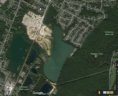
South satellite view of
Mine Hill Lake where a spillway carries water into Randolph Park pond.
Lamington Riverbed reforms to the left of the Mine Hill Lake shoreline on the
bottom left of the lake. (Google Maps)
From there, the waters of the Lamington form wetlands that are home to a number of small
lakes and ponds, Silver Lake, Horseshoe Lake, Black River Pond and others. As
the Lamington River passes by Horseshoe Lake, several branches combine to flow
South towards Chester. At this point the Lamington is known as the Black River.
The Lamington does not regain its name again until it leaves Chester and enters
(or leaves) Hackelbarney State Park. From there it continues South towards
Lamington and beyond, where it finally joins up with the upper Raritan
River near the vicinity of White House, New Jersey.
Along the
way, the Lamington (or Black River it is more commonly known in Morris County)
passes through some of the most beautiful parts of the region and is home to
wildlife refuge areas, lakes, ponds, state, county and municipal parks and
beautiful walking trails. It is a favorite destination for game fishermen,
kayakers and nature enthusiast.
For more
pictures of the Lamington River, check out the Black River Wildlife Management website at: http://chestertownship.org/about-chester-nj/photo-gallery/


Was around that area often as a kid, growing up on South Third Avenue in Mine Hill...
ReplyDeleteIt is a beautiful and peaceful area with a nice walking trail. I don't know why I didn't discover it sooner. I've lived here nearly 35 years.
ReplyDelete